
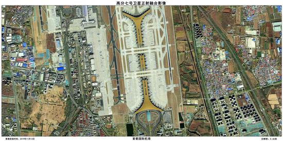
 Photo of Beijing Capital International Airport taken by the Gaofen-7 satellite. The China National Space Administration said yesterday the Earth observation satellite is now officially in service.
The China National Space Administration announced yesterday that the Gaofen-7 Earth observation satellite has officially been put into service, representing significant progress for the country’s surveying and mapping capabilities.
The Gaofen-7 was launched on November 3, 2019 and underwent rigorous testing. It is China’s first civil-use optical transmission 3D surveying and mapping satellite that reaches the sub-meter accuracy level.
Equipped with two line-scan cameras and a laser altimeter, the satellite can provide 1:10,000 scale satellite 3D mapping for users in China and countries participating in the Belt and Road Initiative. That makes it the best in the entire series.
During in-orbit tests, satellite functions such as the monitoring of geographical conditions, agricultural surveys, and road constructions have been verified, said Zhang Kejian, head of the administration.
In May, using data from the Gaofen-7 and Ziyuan III satellites, scientists drew a 1:10,000 scale topographic map for surveyors to measure the height of Mount Qomolangma, also known as Mount Everest.
The Gaofen-7 completed its in-orbit test review on July 23.
A tool with many uses
Since the Gaofen project began in 2010, China has had an increasingly clearer view of the planet. According to the administration, data from the Gaofen series of satellites have been used in more than 20 industries across the country.
Images captured by the Gaofen-2 satellite were used to help monitor the construction work of two makeshift hospitals, Huoshenshan and Leishenshan, in Wuhan in central China’s Hubei Province, after the COVID-19 outbreak.
Gaofen-3 has contributed to the monitoring of the flood situation along Poyang Lake, China’s largest freshwater lake, in east China’s Jiangxi Province.
With Gaofen data, researchers also conducted environmental investigations for poor areas in the northwestern province of Gansu.
“Gaofen-7 will further meet the needs of users in basic mapping, global geographic information, monitoring, and evaluation in urban and rural construction,” said Zhang.
It can provide high-quality data for entire fields of crops, providing detailed information on how they’re distributed.
Wan Guoqiang, director of the Rural Affairs Department of the National Bureau of Statistics said: “Some types of food surveillance should be strengthened in the face of COVID-19 this year. Monitoring shows this year’s rice crops in the south were cultivated and matured earlier than usual, in Jiangxi, Hunan provinces and other southern cities. Gaofen-7 provides more accurate data resources and reinforces our inspection and statistical work.”
Gaofen-7 can also play a role in recognizing the height of objects, meaning better building projects.
Yang Liuzhong, researcher of Remote Sensing Application Center under the Ministry of Housing and Urban-Rural Development said the Gaofen system can help accelerate construction in the transformation of old residential areas.
With only a handful of developed countries having comparable satellite mapping systems, the Gaofen-7 is expected to improve China’s ability to survey and map large scale construction projects.
Gaofen-7 will help solve problems in monitoring geographical conditions, housing and urban-rural construction and national statistics, according to Cao Haiyi, Gaofen-7 chief designer, at the China Academy of Space Technology.
“In the past, surveying and mapping work was labor-intensive and lasted for months or even years. With the new satellite, these tasks can be completed in minutes. Before the launch of Gaofen-7, we could only precisely locate super-highways, but now Gaofen-7 can help us accurately locate rural roads,” Cao said.
(Agencies)